


Geomagnetic Storm to Hit Earth This Weekend
A strong geomagnetic storm is expected over the weekend which can disrupt communications...

SANSA provides important satellite data and products to help the government respond to COVID-19, including data for contact tracing and mapping spaza shops affected by the lockdown.
President Cyril Ramaphosa announced mitigation efforts aided by the Council for Scientific and Industrial Research (CSIR) that require satellite data.
“One of our approaches of dealing with COVID-19 is to ensure that existing SANSA products and services are accessible to government through the CSIR’s #COVID19 Information Centre,” says SANSA’s Managing Director of Earth Observation, Andiswa Mlisa. “We are part of the entities that are working with the CSIR on the coordinated response by the National System of Innovation (NSI) and the Department of Science and Innovation.”
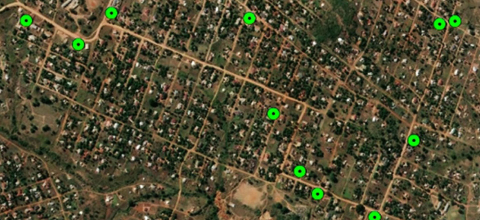
For instance, SANSA ensures that map layers are accurate for human settlements and water bodies – two of the most critical datasets in mitigating the spread of COVID-19. SANSA is also hosting the SANSA AWS Informal Settlements Hackathon that will draw on the expertise of hundreds of data scientists to come up with solutions based on SANSA’s vast amount of earth observation data.
SANSA has directly been engaging with the government, including the Department of Human Settlements.
“The Department of Human Settlements is looking at de-densification of informal settlements to reduce overcrowding, and also to provide water to those settlements,” says Nale Mudau, Remote Sensing Scientist at SANSA. She leads SANSA’s efforts to assist the Human Settlements Department.
“They need information on where informal settlements are located, which is not always available. South Africa does not have a national informal settlement map layer the department can use for their decision-making, hence the need to derive this information from satellite images.”
The Department of Small Business Development wants to know, for example, how far spaza shops are from wholesalers so that the government can assist them during lockdown.
“Such a project takes time because we are unable to identify a spaza shop from satellite images alone,” says Mlisa. “But using participatory GIS (Geographical Information System), citizen science and other means, we can go to those places to find the spaza shops.”
SANSA has developed an app that would make it easy, with lockdown restrictions in mind, to record the locations of spaza shops.
Mlisa says the COVID-19 pandemic has exposed many inadequacies in local government value chains, such as the lack of proper addressing in some parts of major municipalities. This presents a problem when tracing the contacts of a person confirmed to be positive with the coronavirus, as they may be living at or have visited unaddressed locations.
“We can’t address these challenges overnight. There is a lot of engagement that one needs to do with the government, either through the department or at the municipal level, to deploy the solutions we have so that they fit into the business,” says Mlisa. “This is the kind of information that isn’t only useful for COVID-19; it is also useful for the government because if you know where things are, you can better manage them.”
Mlisa hopes that projects such as the one mapping spaza shops can address these challenges to provide solutions for all levels of government and assist in their efforts to curb the spread and effects of the COVID-19 pandemic.
“At the end, we want to develop a decision-support tool with all this information for small business, air quality, human settlements and traffic. It should be put into a portal where users can access that information with the necessary analysis to make decisions,” says Mudau.
The South African National Space Agency (SANSA) in Hermanus leads SANSA’s, Space Science Programme. SANSA forms an integral part of the worldwide network of magnetic observatories and assists in monitoring the near-Earth space environment. Additionally, SANSA also provides vital information on spa...
View ProfileXplorio is your local connection allowing you to find anything and everything about a town.
Read MoreA strong geomagnetic storm is expected over the weekend which can disrupt communications...
(SANSA) is excited to invite the public, local community, and stakeholders to its open day on 5 October 2024.
High school learners from local schools in the Overstrand had the opportunity to meet an international astronaut last week.
You are invited to attend the SANSA Space Talk: Space Weather Impacts on Commercial Space by Prof. Mark Moldwin.
A historic solar storm impacted Earth throughout the night on Friday, 10 May 2023 and continued into Saturday, 11 May 2024.
SANSA hosts local youth for practical experience during their engineering studies.


